Tyne and Wear Metro – Guide to Routes, Tickets and Timetables
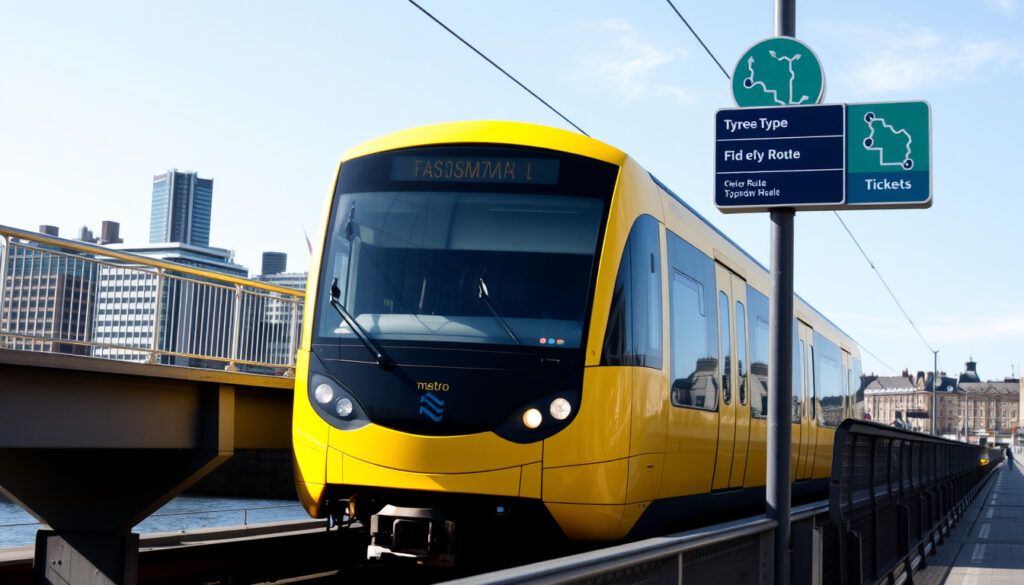
The Tyne and Wear Metro stands as one of the United Kingdom’s most significant urban rail networks, connecting communities across North East England through a comprehensive rapid transit system. Serving Newcastle upon Tyne, Gateshead, Sunderland, and surrounding areas, the network has operated as a vital artery of regional transportation since its phased opening in the early 1980s.
Stretching across both overground and underground sections, the Metro provides essential connections between residential neighbourhoods, commercial districts, and key destinations including Newcastle Airport and the coastal town of Sunderland. With a fleet operating from approximately 05:00 until midnight, the system handles millions of passenger journeys annually, making it a cornerstone of daily life for residents and visitors alike.
This guide covers the essential information travellers need to navigate the Tyne and Wear Metro effectively, from understanding routes and timetables to purchasing tickets and learning about the ongoing modernisation programme that will shape the network’s future.
What is the Tyne and Wear Metro?
The Tyne and Wear Metro represents a pioneering light rail and rapid transit system that transformed public transport in North East England. Originally opened in stages between 1980 and 1984, the network has continuously evolved, with significant extensions adding Newcastle Airport connectivity in 1991 and Sunderland services in 2002.
Network Overview
Newcastle upon Tyne, Gateshead, Sunderland, and surrounding areas
Green Line and Yellow Line
Nexus (Tyne and Wear Passenger Transport Executive)
60 stations across the network
Key Insights
- The Green Line runs from Newcastle Airport to South Hylton, passing through Sunderland and serving Park Lane interchange
- The Yellow Line connects St. James to South Shields along the river corridor
- A high-frequency core section operates between South Gosforth and Pelaw, where both lines combine
- The system divides into three fare zones (A, B, and C), with zonal pricing applying to all journeys
- Peak services can achieve headways of just 3 minutes in the busiest central sections
- The network includes both underground city centre stations and extensive overground sections
- Direct airport connections place Newcastle Airport just 20 minutes from the city centre
Snapshot Facts
| Fact | Details |
|---|---|
| Total Stations | 60 |
| Operating Hours | Approximately 05:00–00:00 |
| Opening Date | 1980 (stages through 1984) |
| Fare Zones | A, B, and C |
| Major Lines | Green Line, Yellow Line |
| Airport Connection | Newcastle Airport (20 mins to city centre) |
Tyne and Wear Metro Timetable and Map
Understanding when services operate proves essential for effective journey planning on the Tyne and Wear Metro. The network operates under different timetables depending on the day of the week, with weekday services providing the highest frequency across both lines.
Weekday Services (Monday–Friday)
Peak morning services between 06:00 and 10:00 see the Green Line running at 5 trains per hour (12-minute intervals) while the Yellow Line operates at double this frequency with 10 trains per hour (6-minute intervals). Combined services in the core section between South Gosforth and Pelaw achieve headways of 3 to 6 minutes during these peak periods.
Daytime services between 10:00 and 18:00 maintain similar frequencies, with peak short workings from stations including Regent Centre, Monkseaton, and Benton enhancing central section capacity. Evening services from 18:00 onwards see reduced frequencies, with the Green Line moving to 4 trains per hour (15-minute intervals) and the Yellow Line at 8 trains per hour (7–8 minute intervals).
Weekend Services
Saturday operations broadly mirror weekday patterns, though early morning services before 09:00 operate at reduced frequencies of approximately 15 minutes per individual line, combining to 7–8 minute intervals in the shared corridor. Sunday services see further reductions, with morning frequencies of just 2–4 trains per hour (30 to 15 minute intervals) improving to 4–8 trains per hour during daytime and evening periods.
First and Last Services
First train times vary by route and direction. The Airport to South Hylton service typically begins around 05:44, while the South Shields to St. James service commences approximately 05:49. Last services vary, with the Airport–South Hylton route typically concluding around 22:42, though extended services operate on certain days. Passengers are advised to consult current timetables from Nexus as schedules may be subject to change.
The Tyne and Wear Metro timetable operates different frequencies depending on the time of day and day of the week. Always verify departure times before travelling, particularly for early morning or late evening journeys when services are less frequent.
Understanding the Metro Map
The Tyne and Wear Metro map illustrates the network’s structure, showing how the Green and Yellow Lines branch from a shared central corridor. Both lines converge between South Gosforth and Pelaw, creating the high-frequency core that provides convenient connections across the metropolitan area.
Key interchange points appear throughout the network, including stations such as Haymarket, Central Station, and Pelaw, where passengers can connect between lines or access other transport modes. The Metro map is available in both schematic and geographical formats, with mobile applications providing interactive versions that include real-time service updates.
Mobile applications such as the Tyne and Wear Metro Map app offer interactive navigation features alongside live updates, helping passengers plan journeys and track services in real time. The official Metro map document published by the government provides a comprehensive overview suitable for detailed journey planning.
How to Buy Metro Newcastle Tickets
Purchasing tickets for the Tyne and Wear Metro involves understanding the zonal fare system that applies across the network. The system divides into three zones (A, B, and C), with ticket prices determined by the number of zones a journey crosses.
Ticket Prices and Fares
Single tickets range from £1.50 for travel within one zone to £3.10 for journeys covering all three zones. Two-zone single tickets cost £2.40. For visitors travelling from Newcastle Airport to the city centre, a single journey costs from £3.60, while an all-zone day ticket provides unlimited travel for £5.30.
The zonal structure means that journeys between Newcastle city centre and Sunderland cross multiple zones, with the Green Line providing services every 20 minutes in the South Hylton direction. This pricing structure applies consistently whether purchasing from ticket machines at stations or through digital channels.
The term “Metrokaart” refers to the zonal maps that show fare boundaries across the network. These maps, available from Nexus and partner sources, display the three zones (A, B, C) and help passengers determine the correct fare for their journey. Visitors should familiarise themselves with zone boundaries before purchasing tickets.
Where to Purchase Tickets
Tickets can be purchased through multiple channels, with ticket machines available at all stations on the network. These machines accept various payment methods and provide single tickets, day tickets, and other travel products. The Nexus website and mobile application offer additional purchasing options for those who prefer digital ticketing.
For visitors arriving at Newcastle Airport, ticket machines at the airport station provide convenient access to travel products, with the direct airport link reaching the city centre in approximately 20 minutes. Season tickets and concessionary passes are available for regular commuters and eligible passengers including senior citizens and disabled travellers.
Tyne and Wear Metro Cars and Rolling Stock
The Tyne and Wear Metro operates a dedicated fleet of trains designed specifically for the network’s unique characteristics, including underground sections, street-level running, and high-frequency operations on the shared central corridor.
Current Fleet and Modernisation
The original Metrocar fleet has served the network since its opening in 1980. However, an extensive modernisation programme is underway to replace the aging trains with new rolling stock from Stadler. The Stadler Nexus trains represent a significant investment in the network’s future, promising improved reliability, accessibility, and passenger comfort.
The modernisation initiative addresses the operational challenges of maintaining a system that has operated for over four decades. New trains incorporate modern features including improved accessibility, better onboard information systems, and enhanced environmental performance. This programme forms part of broader efforts to ensure the Tyne and Wear Metro continues meeting passenger expectations.
Historical Context
The network’s history includes various service patterns, with earlier operational structures featuring what were informally designated as Red and Blue lines serving busier stations with additional peak services. These arrangements evolved over time as passenger demand patterns changed, ultimately consolidating into the current Green and Yellow Line configuration that has characterised the network in recent decades.
The Tyne and Wear Metro modernisation programme represents the most significant investment in the network since its original construction. Passengers can find the latest information about new train introductions and service changes through official Nexus communications and the official Metro social media channels.
Key Milestones in Tyne and Wear Metro History
The development of the Tyne and Wear Metro spans several decades, with each phase bringing new connections and capabilities to the network. Understanding this timeline provides context for the system’s current operations and future direction.
- 1980–1984: Phased opening of the initial network, establishing core connections across Newcastle and Gateshead
- 1991: Extension to Newcastle Airport, providing direct rail access to the region’s main international airport
- 2002: Sunderland extension, expanding the network across the River Wear and connecting to England’s southernmost Tyne and Wear city
- Ongoing: Modernisation programme, with new Stadler Nexus trains gradually entering service to replace aging rolling stock
Each major development has expanded the network’s reach and capability, transforming regional connectivity across North East England. The original infrastructure, designed to serve the urban core, has been progressively enhanced to meet changing travel patterns and regional development priorities.
What We Know and What Remains Uncertain
When examining the Tyne and Wear Metro, certain information is well-established through official sources and public records, while other aspects require further verification or remain subject to change.
| Established Information | Areas Requiring Verification |
|---|---|
| Two main lines (Green and Yellow) serving 60 stations | Specific daily ridership figures (not detailed in available sources) |
| Operated by Nexus, the Tyne and Wear Passenger Transport Executive | Current status of individual ticket enforcement practices |
| Three-zone fare structure with published prices | Precise timeline for complete fleet replacement |
| Stadler Nexus modernisation programme underway | Specific service changes during transition period |
| Operating hours approximately 05:00–00:00 | Details of individual station accessibility features |
The official Nexus website provides authoritative information on current services, fares, and network developments. However, certain operational details, including real-time performance metrics and specific infrastructure modifications, may require direct consultation with Nexus or observation of current on-site conditions.
The Role of the Tyne and Wear Metro in Regional Transport
The Tyne and Wear Metro serves as the backbone of public transport in North East England, connecting communities across a metropolitan area spanning diverse urban and suburban environments. From the bustling Newcastle city centre to coastal destinations including Tynemouth and Whitley Bay, the network provides essential connectivity for daily commuters, students, and visitors exploring the region.
The system’s design reflects the geographical features of the region, incorporating underground sections through the city centre and river crossings that connect communities separated by the River Tyne and River Wear. This infrastructure enables efficient movement across a metropolitan area that would otherwise depend heavily on road transport.
For those comparing regional transport options, the Metro’s integration with other transport modes creates comprehensive journey possibilities. Similar rail connections elsewhere in Britain demonstrate how regional transit systems complement longer-distance rail services, with Metro providing first and last-mile connectivity for intercity journeys.
Official Sources and Further Reading
Several authoritative sources provide information about the Tyne and Wear Metro, each offering distinct perspectives and levels of detail. The official operator, Nexus, maintains the most current information regarding timetables, fares, and service updates.
“The Tyne and Wear Metro serves Newcastle upon Tyne, Gateshead, Sunderland, and the surrounding areas, connecting key destinations including the airport and coastal towns with frequent services throughout the day.”
— Nexus (Tyne and Wear Passenger Transport Executive)
“The system divides into three fare zones, with single tickets ranging from £1.50 to £3.10 depending on the zones travelled.”
— Official Metro Information
Additional sources including the comprehensive Wikipedia entry and the official government Metro map document provide valuable background information and network specifications. The detailed service information available through independent transit websites complements official sources by offering comprehensive timetable breakdowns.
Planning Your Journey on the Tyne and Wear Metro
Whether travelling for work, education, or leisure, the Tyne and Wear Metro provides a reliable framework for navigating North East England. Understanding the basic structure—two main lines, three fare zones, and frequent services in the central corridor—equips passengers to plan effective journeys across the network.
For visitors to the region, the direct airport connection positions the Metro as an important arrival and departure option, while day tickets provide economical access for those wishing to explore multiple destinations. Regular updates from Nexus ensure passengers can access the latest information about service patterns and any temporary changes affecting their travel plans.
Frequently Asked Questions
What is the Tyne and Wear Metro?
The Tyne and Wear Metro is a rapid transit and light rail system serving Newcastle upon Tyne, Gateshead, Sunderland, and surrounding areas in North East England. It operates two main lines (Green and Yellow) across 60 stations, providing frequent services from approximately 05:00 to midnight.
How do I buy tickets for the Tyne and Wear Metro?
Tickets can be purchased from ticket machines at all stations or through the Nexus website and mobile application. Single tickets cost £1.50 for one zone, £2.40 for two zones, and £3.10 for all three zones. Day tickets providing unlimited travel are also available.
What is the Metrokaart Newcastle?
The Metrokaart refers to the zonal maps showing fare boundaries across the Tyne and Wear Metro network. The system operates three fare zones (A, B, C), and the Metrokaart helps passengers determine their correct fare based on their journey’s origin and destination.
What are the Tyne and Wear Metro operating hours?
The Tyne and Wear Metro typically operates from approximately 05:00 until midnight, with first trains around 05:44 from the airport direction and last services varying by route. Sunday services operate at reduced frequencies compared to weekday services.
How often do Tyne and Wear Metro trains run?
During weekday peaks, the Yellow Line operates every 6 minutes (10 trains per hour) while the Green Line runs every 12 minutes (5 trains per hour). In the shared central section, combined services achieve headways of 3–6 minutes. Evening and weekend frequencies are reduced.
What are the Tyne and Wear Metro lines?
The network comprises two main lines: the Green Line runs from Newcastle Airport to South Hylton via Sunderland and Park Lane, while the Yellow Line connects St. James to South Shields. Both lines share a high-frequency central corridor between South Gosforth and Pelaw.
What is happening with Tyne and Wear Metro modernisation?
An ongoing modernisation programme is replacing the original Metrocar fleet with new Stadler Nexus trains. This represents the most significant investment in the network since its original construction, promising improved reliability, accessibility, and passenger comfort.
Does the Tyne and Wear Metro serve Newcastle Airport?
Yes, the Green Line extends to Newcastle Airport, providing direct rail access from the city centre in approximately 20 minutes. A single ticket from the airport to Newcastle city centre costs from £3.60.
Meer gerelateerde berichten
 Eintracht Frankfurt vs Bayern: H2H, History & Stats
 Rock Orchestra by Candlelight: 2026 Dates, Reviews & Setlist
 Bristol City vs Sheffield United Lineups – Confirmed Teams and Report
 Sol de Janeiro 68: Scent, Popularity, Dupes & Review
 Chick-fil-A Belfast: Lisburn & Templepatrick Open
 Xbox Series S Controller – Complete Specs, Compatibility and Setup
 Liverpool F.C. Standings Today: 4th in PL, 3rd in UCL
 Kate Bush Running Up That Hill Lyrics – Meaning, History and Resurgence